Nearmap’s aerial imagery now covers 80 percent of the U.S. population
Nearmap has expanded its United States coverage to more than 80% of the US population. Overall, the Nearmap capture program will cover over 1,740 urban areas within the U.S. with more than 308,000 unique square miles captured annually — obviously super valuable for solar builders doing remote proposals.
“Nearmap customers have asked us to increase the amount of the U.S. that we cover and we’re responding by doubling down on our coverage,” Tony Agresta, General Manager of North America, Nearmap said. “Our clients will have access to 130,000 sq miles of additional unique captured footprint in the U.S.”
Nearmap is one of the top providers of quality aerial imagery, focusing on currency, consistency, coverage, and ease of access. Nearmap imagery is published within days of capture, with 24/7 access through a web app, API or third-party integration. Nearmap has also recently tested the next-generation of its patented aerial camera system, HyperCamera3.
“Around 11,300 customers worldwide rely on Nearmap to be their eye in the sky, and to provide them with the truth on the ground,” Agresta continued. “We’re seeing strong momentum with new and existing customers in the U.S. This massive boost in coverage reflects the broader investment and focus Nearmap has on the strategically important U.S. market.”
Features of the expanded mapping coverage include:
- 130,000 square miles of additional unique captured footprint in the U.S, equivalent to ~63,000 football fields
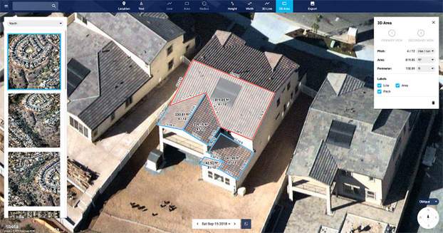
- Double the number of urban areas covered with oblique/3D content
- Access to current content, with updates up to three times a year, including leaf-off and leaf-on collection
- Images at a high resolution ranging from 2.2 to 3 inches
Across the world, Nearmap will also capture over 64% of the population in Canada; over 90% of the population in Australia, and ~73% of the population in New Zealand.

Comments are closed here.